
Gran Canaria is roughly 1,560km2. With half of the island labeled as a Protected Natural Area, the island is perfect if you’re looking to be immersed in nature, and are looking to explore. There are plenty of beautiful and scenic hiking and trekking trails in Gran Canaria, so we’ve compiled some hiking tips and trails for when you decide to hike in Gran Canaria. The hiking season ranges from October to May, so make sure you plan your trip accordingly.

Hiking trails in Gran Canaria are numerous, and the lengths vary from a couple of hundred meters to 25km, so there’s a hiking trail for all ages and experience.
The weather can sometimes be unpredictable, so standard rules apply:
-
Suncream is a must in the Canarian climate.
-
Bring water with you, as temperatures can reach up to the high thirties.
-
Bring a waterproof jacket, the higher altitude and the location of some of these trails means sunshine isn’t always there!
During your hike you encounter picturesque villages with local bars/cafes for a good value post-hiking refreshment. Alternatively, bringing a picnic and setting up on a peak is a beautiful way to spend the afternoon.
Below, we’ve compiled some of our favourite hiking and trekking routes in Gran Canaria, so make sure to check them out! You can always view some of the locations on Google Maps if you’re curious as to how they look, although this is definitely no substitute for the real thing.

Tamadaba – The best preserved pine forests are situated in Tamadaba Natural Park, on the north of the island. At 1,444m above the sea level, you’re offered great views to the northwestern side of the island and all the way to Tenerife.
Bandama – This volcanic crater is close to Las Palmas. The hiking trail can be around the top ring or down into the bottom. The routes are demanding but definitely worth it for the views. During the trekking you can see natural caves and a variety of plants and island birds.
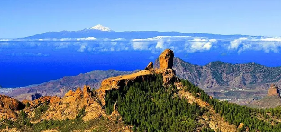
Roque Nublo – This steep cliff of volcanic origin is 80m high and is 1,813m above sea level. It was declared a Protected Natural Space and a rural park. The only higher point of Gran Canaria is Pico de las Nieves standing at 1,949m! Starting from the main road you walk past natural monuments with fantastic views to the lakes/dams. From this point you can also enjoy the stunning view to Tenerife Island. In our opinion, this is the best hiking trail in Gran Canaria.
Las Presas – Towards the south of the island, there is a long trekking route which goes through the Nublo Rural Park and Pilancones Natural Park. This circular walk goes through a pine forest, onto the Soria dam, and along wonderful volcanic formations. Along this route you can also see the traditional cave houses typical for Gran Canaria.
Güigüí Beach – One of the hiking routes to reach Playa de Guigui begins in Tasartico Village placed in Barranco Tasartico. The whole hike to the beach is 3-4 hours long. Fantastic views, with landscapes that look like they’re from another planet and at the end, you’re treated to a black sand beach as a prize for the hike.

If this all sounds a bit daunting for you, there are plenty of tour guides willing to show you through each of these hiking routes (and others). Plus, you’ll even be able to see some hidden gems they can show you! There are plenty of other hiking trails in Gran Canaria, and for some more detailed information, click here for exact distances, altitudes and more.